Wednesday, 29 February 2012

'Crack in the Wall': My Journey from a Charity Bookshop to the Streets of Hong Kong - Part 1


In spring last year I came across a book in a charity shop that caught my eye.  The title of was ‘Crack in the Wall’, a book about the work of Jackie Pullinger, a Christian missionary who went to Hong Kong with little money and nowhere to stay- just with the desire to spread the Christian message.  Although I found her story inspiring, it was the setting that took my interest- the Kowloon Walled City, an urban slum in the centre of Hong Kong.  It was unlike anywhere I had seen before and quite different from other urban slums such as Dharavi in Mumbai – for starters it appeared to have grown upwards rather than outwards.

The Walled City existed as a military base from 1197 when Hong Kong was part of China, and in 1847 the wall from which the Walled City gained its name was built.  In 1898, after the Opium War, when the New Territories were leased to Britain for 99 years, it was decided that China would maintain jurisdiction of the Kowloon Walled City until the British Colonial administration had been established.  In reality, this did not happen and China maintained jurisdiction of the area.  The issue of jurisdiction was the underlying cause of all of the problems in the Walled City – mainly because the British administration was unable to enforce Hong Kong law there since it was technically Chinese territory and the Chinese did not implement Chinese law either.  So, with regards to why the Walled City grew upwards instead of outwards, if it were to grow outwards it would have gone into British territory and therefore would have become subject to Hong Kong law and housing regulation.

As I read more of the book I discovered that the Walled City had been demolished in 1993 – but in some ways this just added allure. It made me wonder what had happened to the 33,000 people who lived there, and this lead to my research question: ‘What were the consequences of the demolition of the Kowloon Walled City’.  Unfortunately, there are very few books on the subject of the Kowloon Walled City, so I decided that the best option would be to travel to Hong Kong and find much of the information myself.
When asked in an email to describe his perceptions of the Kowloon Walled City, Nick Danziger (the photojournalist who took the photographs published in ‘Crack in the Wall’) summed up the key issues very well.

This is what he said:

‘It is cliché to say, but it is hard to imagine.  My overriding impression was: how could so many people live in such a tiny area?  It was cramped, humid and dangerous from a health and safety point of viewpoint with open sewage and electrical wires everywhere.  There was also the ever present danger of people looking to either protect their own rackets or territory and others looking to pounce on any opportunity to prey on the unwary or most unfortunate inhabitants of the Walled City.’

A key reason why the Walled City was not demolished until 1993 was that the clearance was a politically sensitive issue.  The British government had been pushing for its demolition prior to 1987, but the action had always been blocked by the Chinese government and any attempt to demolish the Kowloon Walled City would be likely to cause serious confrontation with detrimental consequences for Sino-British relations – it simply wasn’t worth it.

At this point my research got trickier as colonial records, that I had been using to gain the information, are only released 30 years after they were written meaning that I had no information about what had changed prior to 1987 to allow the demolition to happen.

To find this out, I arranged a meeting with Sir David Akers-Jones who was acting governor of Hong Kong between 1986-1987 and subsequently Chairman of the Hong Kong Housing Authority between 1987 and 1992 – he was the ideal person to speak to as not only was he a key player in the decision to clear the Walled City, but he was also involved in process of clearance and demolition.  The meeting was to be over lunch at the Mandarin Oriental Hotel – his choice, not mine -  and it immediately became apparent that he was not your average 80-something year old and had clearly had an extraordinary life.

The meeting provided a lot of information that I could not have found elsewhere.  As I mentioned earlier, the Chinese government had previously blocked attempts to demolish the Kowloon Walled City; however in 1984, with the signing of the Sino British Joint Declaration which stated that Hong Kong would be returned to China in 1997, the issues surrounding the status of the Kowloon Walled City changed.  China no longer needed to maintain territory in Hong Kong and in fact it was in mutual interest of the British and Chinese to resolve the problems of the Kowloon Walled City once and for all.  So in terms of political consequences of the demolition, there were none at all; if anything, it could have improved relations between the two countries by promoting further cooperation.

A top-down approach was taken towards the demolition process.  This is an approach whereby decisions and actions are undertaken by those in authority with little input from other stakeholders. In fact, prior to the announcement in 1987, only a handful of people knew about the decision to demolish the Kowloon Walled City. Employees of the Hong Kong Housing Authority were only informed on the day of the announcement, after which they immediately had to undertake a census survey of all households living in the Walled City.

The lack of involvement of the residents may evoke negative images of people being forced out of their homes and bulldozers turning up unexpectedly to knock down all of the buildings, but this was not the case and actually the approach appeared to be successful.  Clearly I could not take Akers-Jones’ word for it so it was time for another meeting.  The meeting was with two representatives from the Kowloon Walled City Kai Fong – the resident’s welfare association.  Neither could speak English so I dragged along a couple of my new friends to ask the questions. I recorded the entire interview on a Dictaphone and I must thank my friend Nancy for spending several hours translating the interview when I got back to the UK. 


One of the residents described the day of the announcement:

‘They did it very well.  If they hadn’t surrounded the place, there would’ve been a lot of people coming in and claiming they’d been living there all along.  1 household would have turned into 20/30 households so in that sense it was successful. We could only move out and nothing could move in, not even mattresses.  I was having a perm when people were coming in saying that they have surrounded the place.’

Also, from another meeting with Ian Lambot, who interviewed hundreds of residents before writing his book ‘City of Darkness’, I found out that most of the residents that he spoke to never expected to stay in the Walled City forever.  Therefore when given the opportunity to leave, improving their standard of living, most of the residents were reasonably supportive.  This combined with information from other sources had led me to conclude that in this case, the top-down approach was very successful and in many ways it challenged my prejudices against this approach to redevelopment.

To be Continued…

Imogen 13W

Sunday, 12 February 2012

"Why do we have continents?"

Whilst we were walking to the 6th Form block my friend paused, then asked ‘Immy…why do we have continents?’

I replied, ‘I don’t actually know’. 

Continents are something we learn of from a very early age.  This makes it particularly peculiar that one would not know the answer to my friend’s question.

Evidence suggests that continents were first described by the Ancient Greeks.  Since then, the continents have increased in number from 3 to 7, but the boundary lines between the original continents have stayed broadly similar, with some changes for political and other reasons.


One definition of continents is ‘large continuous discrete masses of land, ideally separated by expanses of water’.  This definition is, however, flawed – take the example of Europe and Asia, which are part of the same land mass. 

But can you imagine calling yourself a Eurasian? 

Others argue that continents are a way of dividing the world culturally.  Yet, are countries such as Pakistan and Japan truly culturally similar?


This generalisation may have worked in years gone by when people knew very little about those on the other side of the globe;  however, today, in our ever more globalised world, when we are ‘Skyping’ our friends in China and we can watch in real time the events in Syria unfold, it has very little meaning.

So having given my friend’s question some thought, I have concluded that today we have continents as a way of explaining the different parts of the world to small children. It is now much more useful to use different and more specific groupings of people and places as these better reflect the needs of the world today rather than those of Ancient Greece.

Imogen 13W

Friday, 3 February 2012

Ice Ice Heist!


The conventional explanation of why glaciers are melting is due to global warming, but now it may be due to theft of ice from glaciers!

Last Friday (27th January) police in Southern Chile arrested a man driving a refrigerated truck which contained 5 tonnes of ice from the Jorge Montt glacier in the Patagonia region of Chile. It was thought to be going to be used for designer ice cubes in bars. This was thought to be because in the capital, Santiago, tourists are served drinks chilled with glacial ice, directly from glaciers. The ice was estimated to be worth £3,900. Police have charged the driver of the refrigerated truck with theft and considering charging him for violation of national monuments.

At the moment, the Jorge Montt glacier in Chile is retreating by half a mile a year and as a result is one of the world’s fastest shrinking glaciers. It's in the Bernardo O’Higgins National Park which is the largest protected area in Chile. There are a wide range of explanations for climate change, but up until now theft wasn’t one of them!

Jane 13Z

Saturday, 21 January 2012

Moving to South Korea


In early February 2011 I left the country I grew up in and headed to my home country- Korea. Everything was new to me in Korea as I didn’t have many memories but I was looking forward to starting a new life there.

 
There are lots of differences between England and Korea starting with how we look. I guess the biggest difference is culture and education. If I introduce briefly about Korea; basically Korea’s capital, Seoul, is a really small city packed with approximately ten million people and as it’s so packed nearly all of us live in apartments. There are lots of schools around the apartment and unlike the schools in England; we have to sit on wooden chairs and wooden tables which are really small. Also in Korea, we have four important tests in a year and when the results come out they give us a rank and that decides our next few months. For example, if I was given 1st then I would be loved more by the teachers and friends than someone who came 50th, like the Olympics. I personally don’t like this education system as it’s teaching us that we have to race with each other to get good grades but I suppose it’s the only way to get approved by the others.

Moving on to culture, we have a special day called chu-seouk in September,which is a bit like memorial day plus thanksgiving day. It’s a day to remember our ancestors and remind ourselves that we are living a perfect life. All of the families get together to have fun while teenagers and kids get money from grandparents.  It’s a great day to have fun and eat a lot of foods!!

Korea has a wonderful culture and hard-working students except the strength to unify. The tension between the North and the South is really huge as everyone knows but having Kim Jong-Il found dead a few days ago, the tension either broke or built another tension. It was a shock to the whole and most of the South Koreans were thrilled and suspicious by the news, nobody knows what will happen but people are certain that this will bring a big turning point to both countries. I really do hope we unify really soon and show our exquisite culture to the world.  

Hayan - Left Camp Hill in Year 8 

Wednesday, 7 December 2011

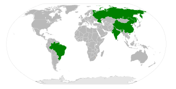
Happy 10th Birthday to the BRICs!

(Image source: Reuters)
Last week marked the 10th anniversary of an economist from Goldman Sachs, Jim O'Neill, coining the term BRICs (Brazil, Russia, India and China), to describe how he believed that these four countries would drive economic growth in the future.  It's strange to think that this presumably informal designation of that time has become so prevalent in Geography, especially in terms of how we look at the world's economic and political development today.

India and China have certainly come a long way in the past ten years, and  will no doubt continue to change the face of the world's power structure in the future.  Russia seems to have remained a hydrocarbon-power in the world, whilst Brazil has perhaps developed its regional dominance over South America.  Either way you look at it though, it's been an interesting ten years and no doubt the acronym will crop up even more in the future.  We'll just have to wait and see as to what the next ten candles on the cake will bring.

Mr. R.

Wednesday, 2 November 2011

Plenty of Environmental Impacts in the Bay of Plenty

When the Liberian-flagged freighter began to leak oil on 11 October, many scientists and environmentalists were worried about the impacts this would have on the environment. Now that several days have passed we are now beginning to see the true extent of the oil spill.
The Bay of Plenty is one of New Zealand’s most prized areas of natural beauty and the estimated 300 tonnes of oil which have been spilt will be extremely damaging. It has been noted that clumps of heavy oil have washed up on beaches such as Mt Maunganui and Papamoa. These affected beaches have been closed, and officials have warned locals not to move the clumps, as this may only make the environmental problem worse.
Many charities and authorities in the local area have reported treating animal and marine life such as blue penguins that have been covered in oil. To care for the animals which have been hurt, the Department of Conservation have created two wildlife rescue centres and dispatched teams to search the beaches and surrounding islands for animals and birds. One of these in in Te Maunga and so far they have reported recovering eight oiled birds. These birds have been covered in ‘sticky black gunk’ which matts their fur. Many birds have ingested this, making them anaemic. So far more than 900 dead birds had been identified, comprising 23 species. These included 458 diving petrels, 198 fluttering shearwaters, 92 Buller's shearwaters, 38 white-faced storm petrels, 20 little blue penguins and 2 shag birds. This could be devastating for species such as the blue penguin, as many of these breed have been affected. For many animals, such as the native birds, the oil spill has occurred in the middle of the breeding season. Also, the oil spill could affect the whales and dolphins that calve in the area, and also the babies which they give birth to.
The damage to the environment will also affect the tourism in the area. The area is known as a particularly good place for fishing, diving and aquatic wildlife. The oil spill has killed and damaged the fish in the area, which will cause the quality of the fish to degrade. If the oil isn’t completely cleaned up, then diving may not be able to done in some areas, as the quality of the water may be dangerous to humans.
Even though the oil spill is occurring as we speak, it is likely that the effects of the oil spill will be felt for many years in the future. This is because many birds which are breeding locally will lose both this breeding season and the next as the birds are likely to be in bad health, damaging breeding ability.
Jane 13Z

Friday, 28 October 2011

Anthropocene - A New Geological Epoch?

You may have heard of the Holocene epoch but have you heard of the Anthropocene, the so-called new epoch of geological time?  The Anthropocene can be defined as the epoch in which human activity has been shaping the earth.

The idea was first proposed in the 1870s by an Italian geologist called Antonio Stoppani but his theory was rejected by other scientists because they thought it was unscientific.  This may have been because the impact of humans at the time was localised and the impacts of anthropogenically caused climate change were not yet known.  In the year 2000, however, Dr Paul Crutzen suggested we are now in the Anthropocene and many scientists took him seriously; the proposal of a new epoch was presented to the International Commission on Stratigraphy, which is the organisation that decides when geological epochs start and finish.

Evidence of the Anthropocene?

Fossils
The main way of identifying periods of geological time is to examine fossils.  Many scientists say that the fossils we leave behind will be vastly different from those of the past.  For instance, because of human land use in the UK, there will be a decrease in fossils of the country’s climax community (deciduous forests) and an increase in agricultural related fossils.  Some scientists suggest there will even be fossils of cities, but others say this would be highly unlikely as cities are built on land, where erosional processes have a greater influence than sedimentation, which normally leads to fossils being created.  Nevertheless, Dr Mike Ellis says that cities may be buried due to sea level rise – he may have forgotten that not all cities are on the coast!

Climate Change
In recent times anthropogenically caused climate change has played a significant role in the shaping of some landscapes.  For example, the melting of glaciers in the Himalayas is now widely believed to have been contributed to by greenhouse gas emissions causing global warming.  This melting has led to increased erosion of the earth’s surface.

Nitrogen Cycle
The Nitrogen Cycle has been severely affected by humans, in particular through the production and use of fertiliser.  This is needed for farming because when crops are harvested, it interrupts the natural recycling of nitrogen (which would normally occur when plants decompose).  Fertiliser leaches into river systems causing algae blooms and this can result in fish being starved of oxygen.  More importantly, the use of fertiliser has allowed the human population of the planet to expand, reaching 7 billion this week. 

However…

Some scientists argue that we cannot just decide when a new epoch has started.  Geology is a historical science therefore an epoch cannot be determined based on predictions.  Moreover, no one can even decide on a start date for the Anthropocene, with different disciplines arguing different dates depending on the particular evidence they have studied.  For example, some ecologists may claim that the Anthropocene began with the development of agriculture around 8,000 years ago; whereas scientists interested in recent climate change may suggest that it began with the Industrial Revolution in the late 1800s.

Does it Matter Anyway?

As many of the processes occurring today do not resemble the Holocene (the epoch we may still be in if the Anthropocene does not exist), it may be useful for many scientists to use the word ‘Anthropocene’ to indicate the period of recent time in which humans have had a significant impact on the earth’s surface.  Some even argue that it is important because it helps emphasise the severity of human impacts on the world and may encourage people to change their behaviour.  Personally I do not think that the International Commission on Stratigraphy should formalise the Anthropocene as a new epoch when we cannot yet be certain of whether or when it has actually started.  It is for future generations to decide when all the evidence is present – that is if humans are still around by then!

Imogen 13W

Tuesday, 4 October 2011

Are Natural Resources a 'Curse'?


In his book ‘The Bottom Billion’, Paul Collier states that ‘about 29% of the people in the bottom billion live in countries in which resource wealth dominates the economy’.  In Nigeria, the largest oil producing country in Africa, the Niger Delta alone provides 80% of the government’s revenue and 95% of export earnings.

Revenues from oil are often far greater than the amount of money countries receive in overseas development aid.  For example, in 2006 Angola’s income increased to over $30 billion because of oil.  This was almost as much as the whole of the African continent received in aid that year.  This may sound like a brilliant solution to the ‘bottom billion’s’ development issues; however, in many countries this has not proven to be the case.

This may seem strange, especially if you consider the benefits natural resources have brought to more developed countries such as Norway and Canada.  Nevertheless, Collier argues that the key difference between these and the ‘bottom billion’ countries is that the ‘bottom billion’ countries lack ‘checks and balances’.  One reason for this is that the resource rich countries have no need to collect taxes from their people, so there is less public scrutiny of government spending in the ‘bottom billion’ nations.  This allows widespread corruption to continue and for the wealth to stay in the pockets of a small minority.  For example, in Angola most of the money has stayed with the richest 5% of the population, with the other 95% living on less than a dollar a day (R. Dowden (2008) ‘Africa: Altered States, Ordinary Miracles’).

You may think that since the spread of democracy to many African countries in the 1990s there will have been better checks and balances so people could benefit from the oil.  However, this is not always the case as resource rich democracies can use ‘politics of patronage’.  This means the governing party bribes people to vote for it because it has the money to do so and can get away with it.  So maybe an autocracy would be better?  Collier argues against this, stating that autocracy only works in societies which are not ethnically diverse. 

Furthermore, an abundance of natural resources can lead to a recurring cycle of conflict because natural resources can motivate and finance conflict.  For example, Nigeria’s Delta region has seen violence occurring since 1998, with militant groups such as the Niger Delta People’s Volunteer Force and MEND fighting to gain control of the oil resources which they believe are rightfully theirs.  The unequal distribution of wealth has been a major factor in triggering the violence.

Another reason for discontent is the devastating environmental consequences of the extraction of natural resources such as oil.  For instance in the Niger Delta pollution is a major problem – over 500 oil spills have occurred in the 5 years to 2010.  If this wasn’t bad enough, oil companies have been known to cause damage and then blame local people for sabotaging the pipelines.

Finally, resource exports cause the countries’ currencies to rise against other currencies.  This means exports become uncompetitive.  For example, in Nigeria in the 1970s oil revenues built up so the value of Nigeria’s currency increased, leading to wage increases, so prices of other exports like peanuts and cocoa also increased.  This meant that people in nations like the UK began to buy their peanuts and cocoa from other countries instead.  ‘Bottom billion’ resource rich countries will therefore find it difficult to follow the route to development taken by countries such as China through manufacturing.

Nevertheless there is reason for optimism as ‘bottom billion’ countries can take steps to make natural resources an opportunity rather than a curse.  In 2004, for example, Nigeria adopted the ‘Extractive Industries Transparency Initiative’ and this appears to be having some positive results.

Imogen (13W)

Thursday, 29 September 2011

Drought and famine in the Horn of Africa

I know that some of you have been following the drought and famine sitaution in Africa over the past few months.  This well constructed infographic gives a succinct summary of the impacts.  

Mr. Revitt

Tuesday, 27 September 2011

Syria Tracker

Before the summer, I undertook some research in preparation for a presentation about the importance of social media such as ‘Facebook’ and ‘Twitter’ during the Arab Spring - the pro-democracy uprisings currently continuing in the Middle East and North Africa.  Whilst doing so, I came across a particularly fascinating website called Syria Tracker.  As a geographer, my interest in this website was sparked by its innovative use of Geographical Information Systems (GIS), similar in appearance to that of police.uk, the UK's local crime and policing website.  

Syria Tracker is a ‘crowdmapping’ website.  Syrians who have witnessed or been affected by human rights and other abuses by the Syrian Government regime can e-mail or Twitter the details to the Syria tracker website administrators who input the information to produce an interactive map.  Furthermore, information is linked onto the map from news reports and other types of social media such as You Tube videos providing an additional spatial dimension. This might be useful, for example, if a concerned relative wishes to find out about all the news and human rights abuses in the area where their family members live: the website will immediately direct them to many news reports and events in the vicinity they are interested in. 

My first impression of this website was that it could bring only benefits for the Syrian people and for outside spectators such as foreign journalists.  For instance the map appears to suggest that the majority of incidents have occurred in the South West of Syria, therefore journalists could be led to conclude that this would be the most appropriate area to target their resources.  However, after a little more consideration I realised that the information cannot be taken on face value.  One reason for this is that the mapping does not take into account the disparities in internet access between different areas.  For instance, it is highly likely that Damascus, which is situated in the South West of Syria, would have a higher level of internet access than the more rural North East.  This may mean that even if there were a higher number of human rights abuses in a small town in the North East of Syria than in Damascus, these might not necessarily get reported and would therefore not be shown on the map. 

More worryingly, there is no way of checking who has provided the information which is used to create the maps or of verifying the accuracy of the information.  For example, the website could potentially be used by a Government to lure protesters to specific locations by ‘faking’ incidents.  Nevertheless the option of anonymity is essential in order to protect the identity of witnesses and victims.

Personally I believe this sort of crowd mapping has many as yet undiscovered uses and will become more widespread in the future.  However, like any statistical information, you need to proceed with caution!
Imogen (13W)